
Heavy rainfall to continue in high risk districts - Met. Dept.
September 9, 2020 08:10 am
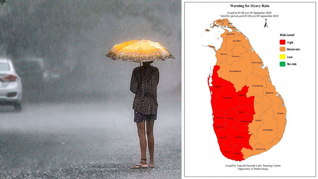
Prevailing showery condition is expected to continue further particularly in the “high risk” districts in Western, Sabaragamuwa, Central and North-western provinces and in Galle and Matara districts.
Heavy rainfalls about 150 mm are likely at some places, according to a warning for heavy rain issued by the Department of Meteorology.
It also said that showers will occur at times in Western, Sabaragamuwa, Central and North-western provinces and in Galle, Matara and Mannar districts while fairly heavy falls about 100 mm are likely at some places.
Several spells of showers may occur in the North-Central province as well. Showers or thundershowers will occur at several places in Uva province and in Ampara and Batticaloa districts after 2.00 pm.
Winds can be fairly strong at times as wind speed can increase up to 50 kmph at times across the island particularly in the Northern, Northcentral and Northwestern provinces and in Trincomalee, Hambanthota, Kandy and Nuwara-Eliya districts.
General public is kindly requested to take adequate precautions to minimize damages caused by lightning activity and localized strong winds during thundershowers.
Sea Areas:
Showers or thunders showers will occur at several places in the sea area around the island, the department said.
Heavy showers may occur in the deep and shallow sea areas off the coast extending from Puttalam to Kaluthara via Chilaw and Colombo.
Winds will be westerly to South-westerly in the sea areas around the island. Wind speed can increase up to 60-70 kmph in the sea areas off the coast extending from Puttalam to Kankasanturai via Mannar.
Wind speed can increase up to 60-65 kmph in the sea areas extending from Matara to Pottuvil via Hambanthota.
The sea areas extending from Puttalam to Mannar and from Matara to Pottuvil via Hambantota will be rough to very rough at times while the other sea areas around the island can be fairly rough at times.
There is a possibility that near shore sea areas off the coast extending from Beruwala to Hambantota via Galle, may experience the effect of swell waves, having 2.5 – 3.5m height.
Naval and fishing communities are requested to be vigilant in this regard.