





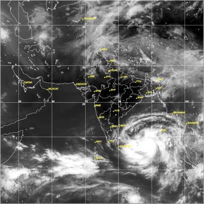



The deep depression in South-East Bay of Bengal has intensified into a Cyclonic Storm and is centered about 900km to the East of Pottuvil. It is most likely to move in the North-westward direction, the Met. Department said.
The deep depression in Southeast Bay of Bengal had intensified into a tropical cyclone ‘Mahasen’ (contributed by Sri Lanka) this morning.
As such eastern and south-eastern sea areas beyond 300km from Pottuvil will experience strong winds (more than 70kms per hour), very rough conditions and intermittent rain.
The Department of Meteorology requested naval and fishing communities to refrain from their activities in the sea area beyond 300Kms (85E) from East coast.
Under the influence of the system fairly strong (40kms per hour) South-westerly winds can be expected over Sri Lanka and neighborhood, the department said in its forecast today.
Prevailing weather can be changed gradually occurring occasional showers in the Western, Sabaragamuwa and Central provinces and Galle and Matara districts.
Regional Specialised Meteorological Centre in New Delhi saw Mahasen intensifying further into a very severe cyclonic storm by Monday.
It is expected to become a severe cyclone later by tomorrow and move northwestwards before re-curving northeast towards Bangladesh-Myanmar coast, according to Indian media reports.
The Joint Typhoon Warning Centre of the US Navy sees ‘Mahasen’ racheting up wind speeds to 157 km/hr gusting to 185 km/hr just before it makes a landfall. The US agency chose Chittagong in East Bangladesh as the likely landfall area.